And every object that might make me fear
Misfortune to my ventures...
- Shakespeare, Merchant of Venice
If you are looking to build your story setting, to develop your imaginary world, to evoke a sense of distance or scale, to add local colour or distant legends, whether it is winding byways or savage wilderness, it always helps to have a map.
A map can be an equally useful tool for both writer and reader. For writers, it provides at least the bare bones of your setting because a map forces the writer to think through the concepts of space, time, population, density, geography, trade, economics, technology, transport, food, climate, culture - the thousand areas that will impact and anchor your characters, your storyline and your plot. These then become the fleshed out detailed world that lurks below your story, providing verve and verisimilitude. It helps deepen your characters - do they travel by foot, horse, cart, boat, or plane? Do they cross plains or deserts or mountains? Are they journeying across town - through a market or a shambles, past churches or trading houses? Is it thronged with crowds, or dark and sullenly empty with suspicion peering from every doorway? How does your character manage this journey? How do they change or develop? How can you show this to the reader and move your plot forward at the same time?
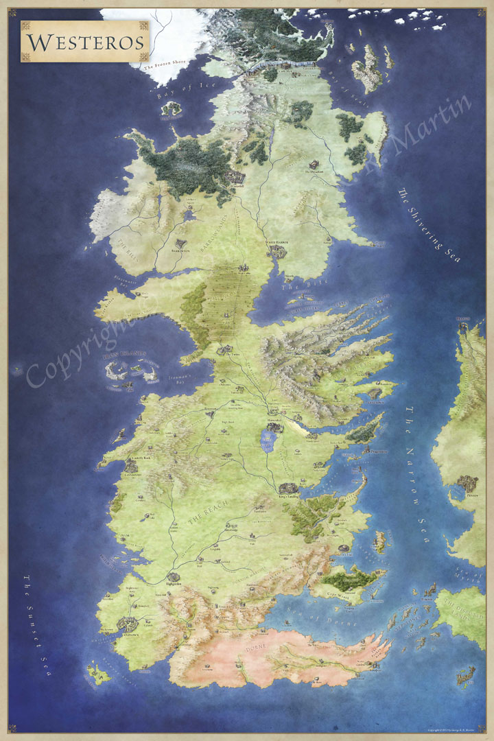
For readers, maps can clarify location, context, and distance. They can show the heroes journey and, in many cases, can become an iconic part of the author's work, adding depth and credibility to the world beyond just a bare-boned description of "distant mountains". Tolkien's Middle-Earth and George R.R. Martin's Westeros would not be nearly as powerful a setting without a clear glimpse for the reader of the various lands and locales. Context builds detail and pulls the reader into the world you are creating.

Maps provide an anchor for a reader, locking the story into the world you are creating. They can be used to guide and direct, to suggest and evoke a much larger world than the one that your story inhabits. It can provide a backstory for your world that can suggest a much wider and grander world is hidden away, locked into unknown or unexplored regions.
This gives the author a broader sweep of the story to work with, and other areas to visit or re-visit for future plotlines or adventures.

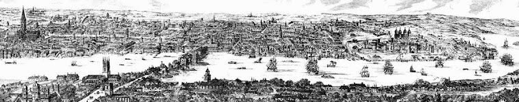
By way of example, my current writing project Thieves Castle is set in Elizabethan London in 1576. Between Elizabethan contemporaries like John Stow (author of A Survey of London (1598), and other writers and maps like the Agas Map of London (c. 1560's), you can develop a clear picture of the geography, population and bustle of Elizabethan London, right down to the cacophonous cries of street vendors ("Hot codlings! Get your hot codlings!") and the stench of offal from the markets of Smithfield. As an added bonus, you can explore the Agas Map online via the University of Victoria's Map of Early & Modern London project.
Here's an excerpt of a description from Thieves Castle that basically owes itself to the cross-fertilization of maps & contemporary sources:
It began before dawn, with the harsh squeal of market-carts and
drovers amputating the quiet dark. The
tramp of early foot traffic rose into a crescendo of sound as the sun edged
above a yellow and grey horizon invisible to most city-dwellers. With the light came a cacophony of trade and
commerce, a cadence both familiar and discordant as the city woke to the new
day. Strident cries warred for
attention, hawking baked apples, cabbages, fish, milk, bread and pie. The distant percussive patina of metalwork
and hammers was overlaid with the sounds of shouts and greetings, dogs barking
and howling, pigs squealing and the bellow of tinkers and knife-sharpeners.
It was the bells that woke him. They rose in a chorus, first St. Clements with a brassy clangor that sent birds skyward and silenced the yelping cries of the neighborhood dogs. Then came St. Martins, lighter in pitch, a plangent tenor that hung a beat behind the nearby St. Clements like a thin sibling. The sound spread like ripples in a pond, the echo’s flitting down alleyways and thoroughfares, as more bells joined in the daily refrain.
Now none of these tools replace the necessity of actually writing obviously. Tolkien's description of the "cruel and ancient spires" and "far over the Misty Mountains cold / To dungeons deep and caverns old" in the song of the Dwarves help evoke a picture of the frozen and soaring savagery of ancient peaks, furrowed with dark secrets and hidden valleys. How his characters then approach and pass through (or under in this case) this formidable barrier drives a key plot element and helps develop and illustrate the characters of the nascent Fellowship of the Ring.
Maps provide depth, context and structure to both the development of a plotline and the characters that inhabit it. They provide writers with guidance, direction and, often a helping hand in knowing what they might want to have their characters do and how they can do it.
Maps can give you direction, and direction can be a critical element in any character's or a writer's journey.
Remember, in the blank spaces on the maps and in the distant seas beyond the borders, here be dragons.

No comments:
Post a Comment